.svg "Greenhatch white logo (1)")


Watercourse cross-sections, commonly referred to as just sections are segments of a body of water take in the vertical plane rather than in the horizontal plane.
They are used as a proxy by construction and flood risk companies to provide invaluable information on watercourse capacity and when modeled with factors such as flow rate can be used to highlight areas that may become susceptible to flooding.
Use of the sonar boat
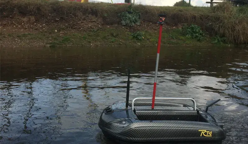
Many water courses have depths that make it impractical/unsafe to survey them on foot. Normally this would mean that an expensive manned boat would have to be launched in order to collect the survey data. However, Greenhatch's bespoke remote-controlled sonar boat allows us to collect more data, faster, with less health and safety risk and often at reduced cost (when compared to conventional surveying methods).
.webp?width=641&height=300&name=download%20(3).webp)
With a wealth of experience, Greenhatch Hydro have previously surveyed a range of different sites from long stretches of high capacity rivers to lakes in active working quarries.
Using our remote controlled sonar boat we are able to collect tens of thousand of points resulting in unrivalled data.
Case Study
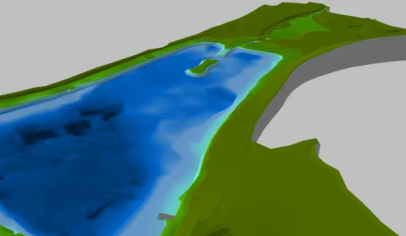
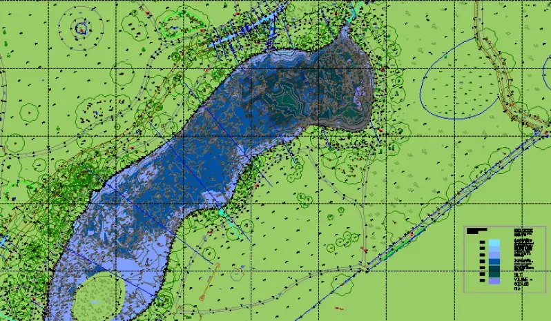
The images on the left come show models of a quarry lake in Denham, UK in which over 14,000 data points were collected across a week to give a 10m x 10m grid across a 1.4km grid.
The benefits of using the remote sonar boat as opposed to traditional methods are as follows:
Data quantity - over 14,000 points taken during the survey.
Data quality - using the echo sounder is far more accurate than the traditional method of poles off a boat.
Speed of survey - a survey that would normally take weeks or even months was completed in just under a week on site and processed in just a few days.
Cost - another benefit of the survey taking less time than conventional methods.
Health and Safety - As the boat is remote controlled we don't have to spend much time in contact or near the water but in this case it meant that we were able to get much closer to working machinery without it presenting any sort of risk to health and safety.
The result: A better quality survey without compromising on cost!


Greenhatch's remote control boat is equipped with an OHMEX Sonamite Transducer. Whilst its position is logged by a theodolite on the shore, the sonamite records depths and the two data sets are then synced. As the sonamite can take up to 1 depth reading a second, it is possible to create highly detailed data sets which are far superior to those collected using traditional methods and this can often be achieved in less time.
An equally important feature of the boat is safety. As it is remotely controlled, this negates most of the health and safety risks associated with working with water.

Our recent projects
Explore similar projects and learn how they were delivered in an timely manner.
What Is A Mobile Mapping Survey And When Do You Need It?
How Does Cross Section Surveying Support Your Infrastructure?
Advantages Of Revit 3D Building Models For Your Projects
.webp?width=150&height=150&name=C.I.C.E.S%20(Chartered%20Institution%20of%20Civil%20Engineering%20Surveyors).webp)
.svg)
.webp?width=150&height=150&name=R.I.C.S%20(Royal%20Institution%20of%20Chartered%20Surveyors).webp)
.webp?width=150&height=150&name=TSA%20(The%20Survey%20Association).webp)