Introduction
The proliferation of terrestrial laser scanners in the as-built survey industry has allowed survey companies to generate vast amounts of accurate, reliable point cloud measurement data quickly and safely, allowing the production of high quality 2D measured survey drawings. However, there are sometimes areas where it may be difficult or impossible for terrestrial based laser scanning to acquire, such as those that may have restricted or unsafe access. In an effort to overcome these difficulties and ultimately increase the coverage of available data, Greenhatch Group took the decision to employ the use of aerial imagery based Structure-from-Motion photogrammetry techniques, utilizing a camera mounted on a Small Unmanned Aerial Systems (SUAS) to work alongside terrestrial laser scanning.
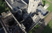
For this project, Greenhatch Group was asked to undertake a full measured building survey of the Grade II* listed Uphill Manor, Weston-Super-Mare, which had recently been devastated by fire, leaving large areas of the building damaged and inaccessible. Built in 1805 and previously known as Uphill, Castle, Uphill Manor is one of the most historic buildings in the area and served as an upmarket hotel prior to the fire. The required output for the survey was a comprehensive set of 2D floor plans, elevations and sections, with additional outputs of aerial images and a 3D mesh model derived from Structure-from-Motion photogrammetry.


Instrument & Software
The on-site terrestrial survey work was undertaken using Z+F 5010c and Faro Focus X330 phase-based scanners, controlled with a Leica Geosystems TS16i total station and georeferenced with a Leica Geosystems GS10 RTK GNSS system. All scan locations would be tied in to the control network using a minimum of 4 black and white checkerboard targets with the centre points coordinated by the total station. Aerial imagery was captured using a DJI Phantom 3 Professional SUAS carrying a 12MP camera and recording Adobe .dng RAW images.
Terrestrial scan data was controlled through LSS and processed with Leica Geosystems Cyclone in a well-tested and accurate workflow. Point clouds were created from the aerial imagery using the Structure-from-Motion photogrammetry program Agisoft Photoscan Professional, and subsequently also imported into Cyclone.
To ensure accuracy and coordination of the terrestrial and aerial point clouds, black and white checkerboard and autorecognition targets were included in the aerial images, with their centre points again recorded by total station. Additional common points were selected and coordinated in both the terrestrial and aerial point clouds for high level areas where physical targeting was not possible.
Why was scanning selected?
After fifteen years capturing metric survey data with terrestrial laser scanners, the Greenhatch Group has developed a site and office workflow which is robust, reliable, and repeatable, and our clients have confidence that this methodology provides accurate results which may be forensically examined for error. For this reason, survey-controlled laser scanning remains the bedrock of our work, producing dense and accurate data from which a number of final outputs can be delivered. It is clear however that terrestrial scanning has limitations, particularly regarding lines of sight and safe access. In this case study it would have been possible to utilise a MEWP or scaffolding platform for the high-level work, but this adds further levels of logistical complexity and potential survey errors. The use of a lightweight and low-cost SUAS drone allowed access to the dangerous burnt portions of the building with little risk to either staff or building structure. Carefully-controlled SfM photogrammetry provided large amounts of additional 3D data, while direct comparison and registration to terrestrial scan data provided confidence in the quality of this data.
What problems were encountered?
Beyond the logistical issues of pilot training, certification, and permissions to fly, Greenhatch Group encountered three principal problems with the production and integration of SUAS point clouds with terrestrial scan data at Uphill Manor. The first was confidence in collection of the right imagery and data on site. This is mitigated only through experience or the collection of far more data than is required, which has implications for processing times and data storage. The second was confidence in the accuracy of point cloud and meshed data produced by the software. SfM software tends to be more ‘black box’ in operation than survey companies and clients may be used to, and at Uphill Manor much more office time than normal was required to be certain that the final point clouds met our quality standards.
Finally, the visual integration of the aerial and terrestrial point clouds required forethought. SfM point clouds generally contain RGB colour but do not have an intensity value, while terrestrial scan point clouds are often captured with intensity only and no RGB colour. At Uphill Manor, integrating the two point clouds meant that all external scan data was captured with RGB colour, necessitating additional site time.
The successful integration of SUAS and terrestrial survey data for the challenging Uphill Manor survey demonstrated the potential of this workflow for similar future projects. Greenhatch Group has subsequently invested further in aerial systems and we continue to refine both data capture and processing.
What were the final deliverables?
The final delivered output was a full 2D floor plans, elevations and sections of the building, carried out to a high detail level, both internally and externally. Within the issued file, we set up sheets for each floor plan including the roof level along with elevations and typical sections in DWG file format. These were then exported as PDF sheets to be viewed by anyone without the required drafting software. In addition to the 2D outputs, a 3D textured model was produced in OBJ file format, along with various aerial images of the site in JPEG format.